About Nuclear Sites Map
The Nuclear Sites Map App was developed by GCS Research, an award winning geospatial technology company based in Missoula, Montana. Map contains approximate buffered (50 and 100 km) locations of world nuclear plants. The...
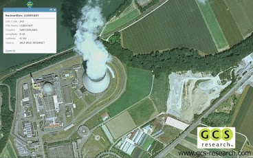
The Nuclear Sites Map App was developed by GCS Research, an award winning geospatial technology company based in Missoula, Montana. Map contains approximate buffered (50 and 100 km) locations of world nuclear plants. The data has not been verified against the nuclear regulatory commission for each country. The map contains data from Esri ArcGIS Online. Quaternary faults and fold data provided by the USGS.This map layer contains locations and information on faults and associated folds, in the United States, that are believed to be sources of significant earthquakes (those of magnitude 6 or greater) during the past 1,600,000 years. A fault is a fracture or zone of fractures in the Earth's crust, along which the blocks of crust have moved relative to one another; an earthquake is the result of such a movement. Folds are curves or bends in rock layers. The Quaternary Faults and Fold database contains information compiled by the Earthquake Hazards Program of the U.S. Geological Survey (USGS). The database describes faults and associated folds in the United States that are believed to be sources of earthquakes, greater than magnitude 6, in the past 1,600,000 years, and is intended to be an archive of historical (less than 150 years) and ancient earthquake sources. Nuclear site data from by the IAEA PRIS INTERNET, U.S. NUCLEAR REGULATORY COMMISSION, and FEDERATION OF AMERICAN SCIENTISTS. Contact GCS Research with your custom Smartphone development needs. www.gcs-research.comGCS Research provides our clients with advanced geospatial information technology, so they can achieve their strategic objectives. We deliver internationally recognized, award-winning solutions through an innovative commitment to the customer’s concept and project requirements. Building upon exceptional service and affordable, industry-leading tools, our success is measured by meeting and exceeding the exacting requirements of our customers.Our portfolio consists of connected "smart" applications and data systems, innovative extensions for industry-leading core platforms, and extensible, integrated Web services. We utilize a standards-based approach to propel next-generation advancements along leading software packages and data resources and help our customers achieve their objectives through a combination of experience, innovation, and commitment to excellence. By building upon the software and data technologies of our strategic partners in the industry, GCS Research cultivates end-to-end geospatial solutions at the height of GIS evolution. Using Service-Oriented Architecture (SOA) and Web service protocols, our clients easily access and share geographic and related content across distributed networks, removing historical barriers to decision-making, analysis, and collaboration. GCS clients include a blend of commercial and government organizations. We deliver a diverse range of geospatial applications, advanced research and development activities, and strategic consulting services. GCS focuses upon the communication, analysis, and exploitation of geospatial intelligence for a dynamic, high-performance user experience. Our success is measured by meeting and exceeding the exacting requirements of our customers.
Previous Versions
Here you can find the changelog of Nuclear Sites Map since it was posted on our website on 2013-08-21 17:31:24.
The latest version is 1.1 and it was updated on 2024-04-19 20:39:41. See below the changes in each version.
Nuclear Sites Map version 1.1
Updated At: 2012-04-27
Nuclear Sites Map version 1.1
Updated At: 2012-04-27
Changes: Several fixes and updates
Disclaimer
Official Google Play Link
We do not host Nuclear Sites Map on our servers. We did not scan it for viruses, adware, spyware or other type of malware. This app is hosted by Google and passed their terms and conditions to be listed there. We recommend caution when installing it.
The Google Play link for Nuclear Sites Map is provided to you by apps112.com without any warranties, representations or guarantees of any kind, so access it at your own risk.
If you have questions regarding this particular app contact the publisher directly. For questions about the functionalities of apps112.com contact us.